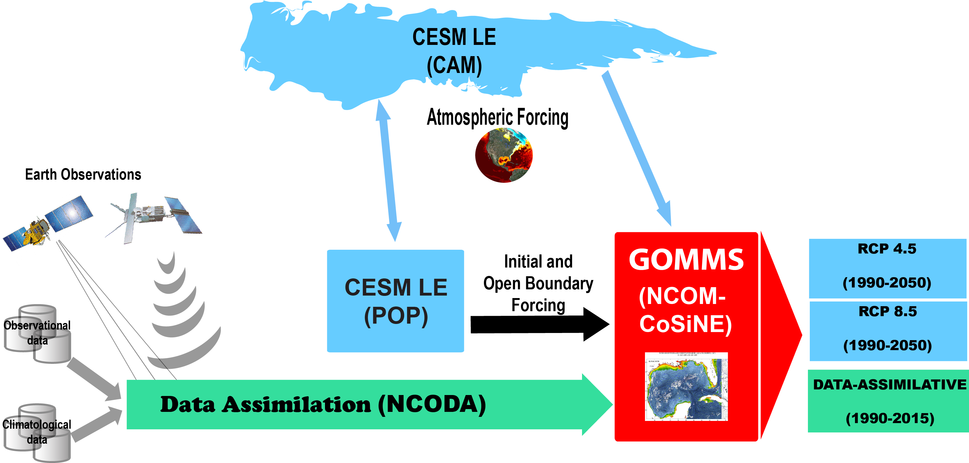
The Model Component diagram summarizes the system flow and integration of the many data, models, and systems that have been developed at NRL and partner institutions.
The physical circulation is simulated by the Navy Coastal Ocean Model (NCOM) [Martin, 2000; Martin et al. 2009] which is coupled to the Carbon Silicate Nitrogen Ecosystem (CoSiNE) Model [Chai et al. 2002; Chai et al. 2003; Dugdale et al. 2002] to simulate the marine biogeochemistry. NCOM is the primary regional general circulation numerical ocean model used at NRL for scientific inquiry and operational support. NCOM makes use of the Navy Coupled Data Assimilation (NCODA) system [Cummings and Smedstad, 2013; Cummings 2011; Cummings 2005] to assimilate satellite-derived sea surface height and temperature data as well as available in-situ observations.
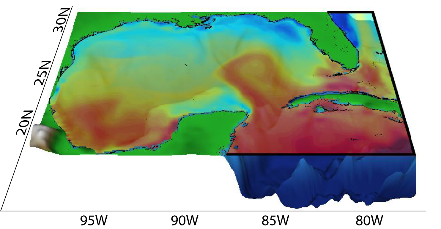
The Gulf of Mexico (GOM) regional NCOM-COSINE ocean model is implemented on a Mercator grid at 1/25° horizontal (equatorial) resolution (~3.5 Km at mid latitudes) extending from 18° to 31° North, and from 77° to 98° West. The model domain covers the entire Gulf of Mexico, reaching farther east (and south) to encompass the entire state of Florida(and to provide a smooth open boundary transition. The inclusion of the Northwest Caribbean is important for simulating the thermal characteristics of waters entering the Gulf through the Yucatan Strait. The vertical grid is configured with a 40 level σ-z vertical structure: 19 σ-layers at the top of the water column, and 21 z-levels at the bottom. The terrain-following levels, reaching from the surface to about 137 meters, allow higher vertical resolutions for resolving coastal processes in the highly mixed shallow waters, while the relatively lower-resolution z-levels are used in the deeper stratified ocean. This configuration optimizes computer resource utilization, allowing multiple decadal simulations to be feasibly made by concentrating the computational power for resolving upper ocean properties, the most dynamic and critical in decision making. The model incorporates a realistic bathymetry derived from the Naval Research Laboratory’s 2-minute Digital Bathymetry Data Base (DBDB2) with the land/sea boundary set at the 2 meter isobath. DBDB2 is a state of the art global bathymetry database constructed from a combination of sources (e.g., soundings) and carefully conditioned and tailored to NRL’s global and regional ocean modeling needs
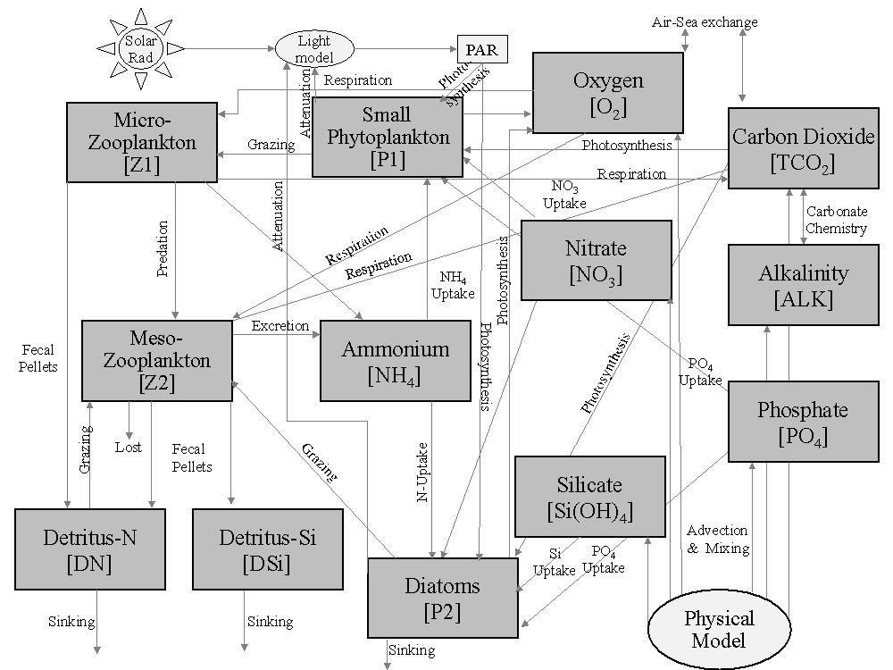
Component diagram of the COSiNE Ecosystem model currently coupled to the physical ocean model.
The NCOM ocean circulation model is coupled to the CoSiNE (Carbon, Silicate, Nitrogen Ecosystem) model [Chai et al. 2002; Chai et al. 2003; Dugdale et al. 2002]. This lower trophic ecosystem model has been progressively enhanced by improved formulations and addition of components [Chai et al. 2007], optical schemes [Lee et al. 2005; Penta et al. 2008], more sophisticated ecosystems [Liu and Chai, 2009] and optimized parameterizations [Fujii et al. 2007]. In this implementation, the CoSiNE ecosystem model incorporates a 13-component biogeochemistry core, which includes phytoplankton and nutrient dynamics (silicate, nitrate, phosphate, and ammonium); two phytoplankton groups (small and large); two zooplankton grazers; two detrital pools; alkalinity, CO2, and O2. Below the euphotic zone, sinking particulate organic matter is converted to inorganic nutrients via regeneration processes. CoSiNE is coupled to the physical model in lock-step (i.e. it exchanges information at each model numerical time step) and generates results at the same frequency and on the same grid as the physical model.
HOME
The Naval Reasearch Laboratory - Stennis Space Center: 7330 Ocean Sciences
Disclaimer: The results herein are derived from ongoing NRL research and development and are not considered "operational". Availability, service, or timely delivery of data are not guaranteed.
Point of Contact
Sergio deRada